Safer cycling across the Dublin region is now easier to plan with the release of the updated cycle infrastructure dataset by the National Transport Authority (NTA). This enhanced open data resource maps all existing cycling infrastructure in the Dublin Metropolitan Area, showcasing the region’s ongoing commitment to active travel. The dataset is available here: Dublin Metropolitan Area Cycle Infrastructure 2025
First published in 2023, the latest version of the cycle infrastructure dataset captures key additions and upgrades completed over the past two years plus infrastructure that wasn’t previously mapped. The categories of cycle infrastructure included in the data are:
- Segregated cycle track and protected cycle lane (one-way or two-way)
- Signed quietways (on low-speed and low-traffic streets)
- Greenways & traffic-free (cycle routes away from the road)
- Footway-level cycle track (cycle track level with footpath without physical segregation)
- Cycle lane (with dashed or solid white lines)
- Footpath with shared use (pedestrians and cyclists share alongside a road)
There has been a notable increase of approximately 50 km in segregated cycle infrastructure across the Greater Dublin Area.
The pace of cycle infrastructure expansion illustrates coordinated action by the Dublin Local Authorities to respond to rising demand for sustainable mobility options. From new greenway cycle routes to the completion of projects like Clontarf to City Centre, the new dataset reflects a tangible shift in how space is being allocated on Dublin’s streets.
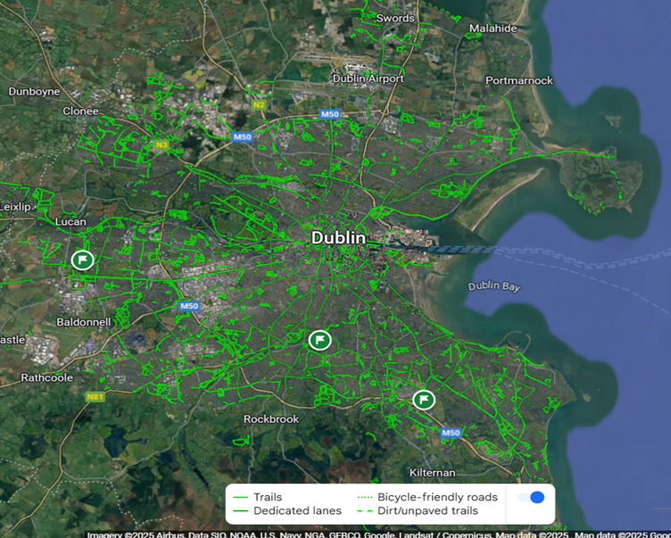
This new Cycle Infrastructure dataset has also been ingested into the Google Maps product, as highlighted in the image below.
This new Cycle Infrastructure dataset was a significant piece of work, with inputs from the Dublin Local Authorities and cross-referenced multiple sources, including Google Street View, Open Street Maps, and the NTA end-of-year metrics. It is a snapshot in time and additions or corrections will be captured in the next update cycle.
To complement the above, Smart Dublin will be capturing new Google Streetview footage for many of the new Greenways & traffic free routes – this footage will enable even more informed journey planning when choosing to walk or cycle.
The dataset also supports a broader trend – cycling in Dublin is becoming safer, more connected, and more viable for everyday use. Check out Smart Dublin’s Active Travel Dashboard to see the positive impact of Active Travel (Walking & Cycling) for your area.
The NTA plan to have future datasets covering the 5 metropolitan areas – with separate shapefiles – the Metropolitan Areas (Galway, Limerick, Cork, Dublin and Waterford) which are defined by the Regional Spatial and Economic Planning Strategies.